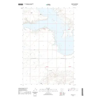
2020 Map of Lothair SW
USGS Topo · Published 2020About this map
Lake Elwell dominates the central-eastern portion of this Liberty County landscape, its intricate shoreline carving deep into the surrounding prairie. This modern survey reflects the importance of water management and transportation in the High Line region of Montana. The terrain is characterized by a series of significant drainage features including Emerson Coulee, Bishop Coulee, and Smith Coulee which feed into Willow Creek and the reservoir itself. To the south, Timber Coulee and Pondera Coulee mark the more dissected topography below the primary heights. A systematic grid of section lines and rural routes, such as 4800 Rd S and 200 Rd E, provides the infrastructure for the local agricultural economy, while Mountain Highway 366 serves as a major east-west connector across the northern plains.
Find a feature on this map
15 named features on this map. Tap any name to fly to it.
Don’t see what you’re looking for? This feature index may not catch every label — zoom into the map to look around manually.
Map Details
Editions of this 2020 Lothair SW Map
This is the sole edition of this map. No revisions or reprints were ever made.
Other maps of this area

1954 · Shelby
USGS Topo · 1:250,000

1958 · Shelby
USGS Topo · 1:250,000

1970 · Carlson Coulee
USGS Topo · 1:24,000

1970 · Knees NE
USGS Topo · 1:24,000

1970 · Uphill Creek
USGS Topo · 1:24,000

1970 · Sagebrush Coulee
USGS Topo · 1:24,000

1970 · Pondera School
USGS Topo · 1:24,000

1970 · Galata
USGS Topo · 1:24,000

1970 · Lothair SW
USGS Topo · 1:24,000
1970 · Lothair
USGS Topo · 1:24,000