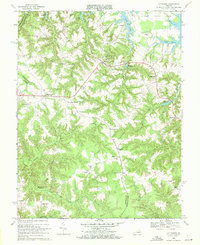
1968 Map of Lottsburg
USGS Topo · Published 1971About this map
Callao and Lottsburg serve as the primary hubs in this late-1960s survey of the Northern Neck region, where the landscape is defined by the complex drainage systems of Lodge Creek and Glebe Creek. The map documents a rural society deeply connected to its coastal hydrology, evidenced by numerous named water features like Headleys Millpond and Fallins Millpond. Local transit and commerce are anchored by historic crossroads such as Village, Walmsley, and Coan Stage, while the social fabric is marked by a high density of country churches, including Henderson Ch, Lively Hope Ch, and Bethany Ch. The presence of several family-named landmarks like Burtons Corner and Reynolds Corner provides significant value for genealogists tracing property and settlement patterns in Northumberland Co and Richmond Co.
Find a feature on this map
48 named features on this map. Tap any name to fly to it.
Don’t see what you’re looking for? This feature index may not catch every label — zoom into the map to look around manually.
Map Details
Editions of this 1968 Lottsburg Map
Other maps of this area

1892 · Piney Point
USGS Topo · 1:62,500

1894 · Piney Point
USGS Topo · 1:62,500

1894 · Point Lookout
USGS Topo · 1:62,500

1895 · Nomini
USGS Topo · 1:125,000

1895 · Piney Point
USGS Topo · 1:62,500

1898 · Nomini
USGS Topo · 1:125,000

1898 · St. Marys
USGS Topo · 1:125,000

1901 · Piney Point
USGS Topo · 1:62,500

1906 · St. Marys
USGS Topo · 1:125,000

1912 · Point Lookout
USGS Topo · 1:62,500