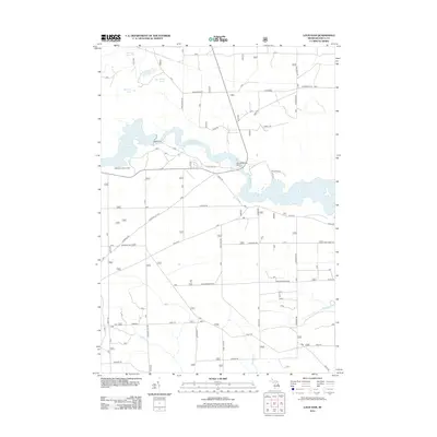
2012 Map of Loud Dam
USGS Topo · Published 2012About this map
The Loud Dam and its expansive Loud Dam Pond anchor this portion of the Au Sable River valley in Iosco County. This 2012 survey captures the hydraulic infrastructure and recreational geography of the region, including the Five Channels Dam and the northern reaches of Cooke Dam Pond. The landscape is defined by the high bluffs of the river corridor, where the Rollways Lookout Tower and Iargo Springs provide key vantage points and water sources. North of the river, a network of lakes including Mitchell Lake, Goose Lake, and Perch Lake sits amidst a grid of forest and county roads. The transport network, featuring Bissonette Rd and National City Rd, reflects the modern management of these timberlands and watershed areas, while smaller tributaries like Vaughn Cr and Graham Cr drain the southern forested tracts.
Find a feature on this map
41 named features on this map. Tap any name to fly to it.
Don’t see what you’re looking for? This feature index may not catch every label — zoom into the map to look around manually.
Map Details
Editions of this 2012 Loud Dam Map
This is the sole edition of this map. No revisions or reprints were ever made.
Other maps of this area

1954 · Tawas City
USGS Topo · 1:250,000

1958 · Tawas City
USGS Topo · 1:250,000

1959 · Tawas City
USGS Topo · 1:62,500

1959 · Glennie
USGS Topo · 1:62,500

1968 · Hale
USGS Topo · 1:24,000

1968 · Hale SE
USGS Topo · 1:24,000

1972 · Alcona Dam Pond
USGS Topo · 1:24,000

1983 · Hubbard Lake
USGS Topo · 1:100,000

1984 · Tawas City
USGS Topo · 1:100,000
1989 · Glennie
USGS Topo · 1:24,000