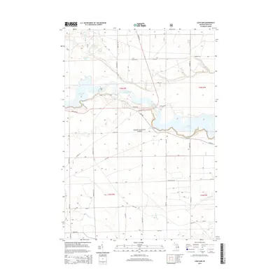
2014 Map of Loud Dam
USGS Topo · Published 2014About this map
Loud Dam and the Au Sable River corridor define this portion of the Huron National Forest as it appeared in the early 21st century. The map documents a heavily managed hydroelectric landscape where the river is transformed into a sequence of reservoirs including Loud Dam Pond, Five Channels Dam Pond, and Cooke Dam Pond. These impoundments are connected by a network of forest roads such as Loud Dam Rd and Iargo Rd, which serve both industrial and recreational access.
Find a feature on this map
46 named features on this map. Tap any name to fly to it.
Don’t see what you’re looking for? This feature index may not catch every label — zoom into the map to look around manually.
Map Details
Editions of this 2014 Loud Dam Map
This is the sole edition of this map. No revisions or reprints were ever made.
Other maps of this area

1954 · Tawas City
USGS Topo · 1:250,000

1958 · Tawas City
USGS Topo · 1:250,000

1959 · Tawas City
USGS Topo · 1:62,500

1959 · Glennie
USGS Topo · 1:62,500

1968 · Hale
USGS Topo · 1:24,000

1968 · Hale SE
USGS Topo · 1:24,000

1972 · Alcona Dam Pond
USGS Topo · 1:24,000

1983 · Hubbard Lake
USGS Topo · 1:100,000

1984 · Tawas City
USGS Topo · 1:100,000
1989 · Glennie
USGS Topo · 1:24,000