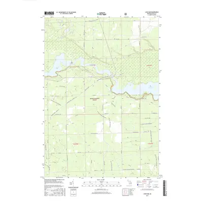
2017 Map of Loud Dam
USGS Topo · Published 2017About this map
The Loud Dam and its associated reservoir, Loud Dam Pond, form the centerpiece of this landscape within the Huron National Forest. This section of Iosco County is defined by a series of hydroelectric impoundments along the Au Sable River corridor, including Five Channels Dam Pond and Cooke Dam Pond. The terrain is crisscrossed by an extensive network of recreational routes, such as the Highbanks Trail and the Mi Shore to Shore Horse&Hike trail, reflecting the area's transition into a major center for outdoor heritage. North of the river, glacial kettle lakes like Mitchell Lake, Goose Lake, and Slab Lake are connected by forest roads, while to the south, the headwaters of Vaughn Cr and Graham Cr drain through a more structured grid of rural roads and forest service tracks.
Find a feature on this map
47 named features on this map. Tap any name to fly to it.
Don’t see what you’re looking for? This feature index may not catch every label — zoom into the map to look around manually.
Map Details
Editions of this 2017 Loud Dam Map
This is the sole edition of this map. No revisions or reprints were ever made.
Other maps of this area

1954 · Tawas City
USGS Topo · 1:250,000

1958 · Tawas City
USGS Topo · 1:250,000

1959 · Tawas City
USGS Topo · 1:62,500

1959 · Glennie
USGS Topo · 1:62,500

1968 · Hale
USGS Topo · 1:24,000

1968 · Hale SE
USGS Topo · 1:24,000

1972 · Alcona Dam Pond
USGS Topo · 1:24,000

1983 · Hubbard Lake
USGS Topo · 1:100,000

1984 · Tawas City
USGS Topo · 1:100,000
1989 · Glennie
USGS Topo · 1:24,000