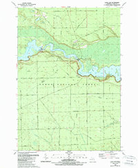
1989 Map of Loud Dam
USGS Topo · Published 1989About this map
The Au Sable River corridor in Iosco County dominates this late-twentieth-century landscape, showing a sophisticated network of hydroelectric infrastructure within the Huron National Forest. The river's course is defined by a series of impoundments including Loud Dam Pond, Five Channels Dam Pond, and Cooke Dam Pond, each supported by industrial features like the Loud Dam power plant and Five Channels Dam. This survey captures a moment when the region's economy had transitioned from timber toward recreation and energy, evidenced by the extensive snowmobile trails and picnic areas near Iargo Springs. The southern portion of the map reveals a more open landscape in Plainfield, where seasonal roads like Kokosing Road and Esmond Road cross drainage features such as Vaughn Creek and Trout Creek.
Find a feature on this map
50 named features on this map. Tap any name to fly to it.
Don’t see what you’re looking for? This feature index may not catch every label — zoom into the map to look around manually.
Map Details
Editions of this 1989 Loud Dam Map
This is the sole edition of this map. No revisions or reprints were ever made.
Other maps of this area

1954 · Tawas City
USGS Topo · 1:250,000

1958 · Tawas City
USGS Topo · 1:250,000

1959 · Tawas City
USGS Topo · 1:62,500

1959 · Glennie
USGS Topo · 1:62,500

1968 · Hale
USGS Topo · 1:24,000

1968 · Hale SE
USGS Topo · 1:24,000

1972 · Alcona Dam Pond
USGS Topo · 1:24,000

1983 · Hubbard Lake
USGS Topo · 1:100,000

1984 · Tawas City
USGS Topo · 1:100,000
1989 · Glennie
USGS Topo · 1:24,000