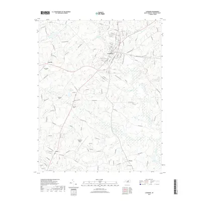
2019 Map of Louisburg
USGS Topo · Published 2019About this map
Louisburg serves as the central hub of this Franklin County landscape, where the Tar River snakes past the historic town center. The settlement pattern reveals a transition from the dense street grid of the county seat to outlying communities like Katesville and Royal. Local history is anchored by landmarks such as Oakwood Cem and the river crossings at Timberlake Bridge and Perry Mill Bridge, reflecting decades of transit and trade. The southern reaches of the quadrangle are characterized by numerous small watercourses including Wolfpen Br, Cedar Creek, and Crooked Cr, which feed into larger bodies like Alford Brothers Pond. Modern infrastructure is also evident, most notably at the Triangle North Executive Airport, showing the evolution of regional transportation alongside traditional agricultural land use and family-named landmarks.
Find a feature on this map
128 named features on this map. Tap any name to fly to it.
Don’t see what you’re looking for? This feature index may not catch every label — zoom into the map to look around manually.
Map Details
Editions of this 2019 Louisburg Map
This is the sole edition of this map. No revisions or reprints were ever made.
Other maps of this area

1902 · Spring Hope
USGS Topo · 1:62,500

1904 · Springhope
USGS Topo · 1:62,500

1953 · Raleigh
USGS Topo · 1:250,000

1953 · Greensboro
USGS Topo · 1:250,000

1954 · Greensboro
USGS Topo · 1:250,000

1954 · Raleigh
USGS Topo · 1:250,000

1962 · Greensboro
USGS Topo · 1:250,000

1966 · Greensboro
USGS Topo · 1:250,000
1967 · Rolesville
USGS Topo · 1:24,000

1968 · Bunn West
USGS Topo · 1:24,000