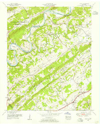
1953 Map of Lovell
USGS Topo · Published 1955About this map
The U S Atomic Energy Commission (Oak Ridge Area) occupies the northwestern corner of this 1953 landscape, marking a period of intense federal activity near the Clinch River. This industrial presence contrasts with the traditional rural character of Beaver Valley and Hardin Valley, where small settlements and family landmarks define the terrain. The map traces the winding course of the river through Cruickshank Bend and past Holt Island, highlighting the topographical barriers of Copper Ridge and Blackoak Ridge.
Find a feature on this map
72 named features on this map. Tap any name to fly to it.
Don’t see what you’re looking for? This feature index may not catch every label — zoom into the map to look around manually.
Map Details
Editions of this 1953 Lovell Map
2 editions found
Other maps of this area

1893 · Briceville
USGS Topo · 1:125,000

1895 · Loudon
USGS Topo · 1:125,000

1895 · Briceville
USGS Topo · 1:125,000

1896 · Briceville
USGS Topo · 1:125,000

1935 · Lenoir City
USGS Topo · 1:24,000

1935 · Bethel Valley
USGS Topo · 1:24,000

1935 · Bearden
USGS Topo · 1:24,000

1935 · Lovell
USGS Topo · 1:24,000

1936 · Louisville
USGS Topo · 1:24,000

1936 · Windrock
USGS Topo · 1:24,000