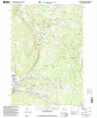
1996 Map of Lovering Mountain
USGS Topo · Published 2000About this map
Colebrook and Stewartstown Hollow anchor this 1990s terrain, where the northern New Hampshire landscape is defined by the valley of the Mohawk River and the West Branch. The U.S. Forest Service updated this survey to reflect the complex management of National Forest lands and private inholdings. Significant local landmarks include the Fish Hatchery and Sewage Disposal Ponds near the Vermont border, alongside recreational points like the Golf Course and several small ponds including Matthews Pond and Lombard Pond. Numerous named peaks like Lovering Mountain, Mudget Mountain, and Piper Hill dominate the topography, while a network of Snowmobile Trails crisscrosses the high ground between Bishop Brook and Cedar Brook. The presence of Beaver Brook Falls and Roadside Park suggests a region oriented toward both local industry and seasonal tourism during this era.
Find a feature on this map
45 named features on this map. Tap any name to fly to it.
Don’t see what you’re looking for? This feature index may not catch every label — zoom into the map to look around manually.
Map Details
Editions of this 1996 Lovering Mountain Map
This is the sole edition of this map. No revisions or reprints were ever made.
Other maps of this area

1925 · Indian Stream
USGS Topo · 1:48,000

1926 · Indian Stream
USGS Topo · 1:62,500

1927 · Indian Stream
USGS Topo · 1:62,500

1929 · Averill
USGS Topo · 1:62,500

1930 · Dixville
USGS Topo · 1:62,500

1933 · Dixville
USGS Topo · 1:62,500

1934 · Dixville
USGS Topo · 1:62,500

1949 · Jackman
USGS Topo · 1:250,000

1950 · Lewiston
USGS Topo · 1:250,000

1953 · Averill
USGS Topo · 1:62,500