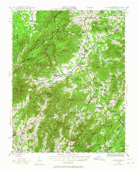
1943 Map of Lovingston
USGS Topo · Published 1965About this map
Lovingston sits at the foot of the Blue Ridge mountains in this mid-century survey of Nelson County. The landscape is defined by the sharp transition from high peaks like Three Ridges and Humpback Mtn down to the fertile basins of the Rockfish River and its numerous forks. This era shows a rural economy deeply rooted in the mountain gaps and valley floors, where small communities like Massies Mill, Nellys Ford, and Batesville are connected by winding roads and the Southern Railway corridor. The western edge of the map is dominated by the George Washington National Forest, with the Appalachian Trail following the high ridges. Dozens of country schools and churches, including Rockfish Valley School and Mt Zion Church, appear alongside old landmarks like Stockton Mill, reflecting a settlement pattern centered around water power and agricultural valleys before modern development reshaped the region.
Find a feature on this map
104 named features on this map. Tap any name to fly to it.
Don’t see what you’re looking for? This feature index may not catch every label — zoom into the map to look around manually.
Map Details
Editions of this 1943 Lovingston Map
2 editions found

Other maps of this area

1892 · Buckingham
USGS Topo · 1:125,000

1892 · Harrisonburg
USGS Topo · 1:125,000

1894 · Staunton
USGS Topo · 1:125,000

1894 · Lexington
USGS Topo · 1:125,000

1929 · Covesville
USGS Topo · 1:62,500

1931 · University
USGS Topo · 1:62,500

1934 · Waynesboro
USGS Topo · 1:48,000

1935 · Amherst
USGS Topo · 1:48,000

1935 · Covesville
USGS Topo · 1:62,500

1935 · University
USGS Topo · 1:62,500