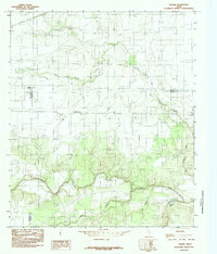
1984 Map of Lowake
USGS Topo · Published 1984About this map
The small unincorporated community of Lowake serves as the focal point of this West Texas survey, situated where the borders of Tom Green, Runnels, and Concho Counties converge. The landscape is defined by the eastward flow of the Concho River, which is joined by Little Concho Creek and Lipan Creek amidst a network of draws including Deep Hollow and Dry Hollow. Evidence of local industry and infrastructure is visible through numerous Gravel Pits, agricultural Storage Bins, and a prominent UG Pipeline cutting across the terrain. Of particular interest to surveyors and historians is the Coline Marker, a distinct geodetic reference point located west of the townsite. The map reflects a rural Texas ranching and farming environment in the early 1980s, documenting water features like Chandler Lake and the shifting elevations of the Concho valley.
Find a feature on this map
14 named features on this map. Tap any name to fly to it.
Don’t see what you’re looking for? This feature index may not catch every label — zoom into the map to look around manually.
Map Details
Editions of this 1984 Lowake Map
This is the sole edition of this map. No revisions or reprints were ever made.
Other maps of this area

1891 · Hayrick
USGS Topo · 1:125,000

1892 · San Angelo
USGS Topo · 1:125,000

1892 · Eden
USGS Topo · 1:125,000

1892 · Ballinger
USGS Topo · 1:125,000

1894 · Hayrick
USGS Topo · 1:125,000

1896 · Eden
USGS Topo · 1:125,000

1921 · Baker Flat
USGS Topo · 1:31,680

1921 · Lowake
USGS Topo · 1:31,680

1921 · Spur Creek
USGS Topo · 1:31,680

1921 · Rowena
USGS Topo · 1:31,680