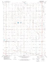
1976 Map of Lowe
USGS Topo · Published 1978About this map
The high plains of western Kansas are defined by a complex network of resource extraction and irrigation infrastructure in the late 1970s. The landscape across the townships of Terry, Sherlock, and Garden City is heavily shaped by the presence of a sprawling Oil and Gas Field, with numerous individual gas and oil wells dotting the sections. Transportation and utility corridors are prominent, including the Atchison Topeka and Santa Fe railroad line and a major Ditch system reflecting the region's agricultural reliance on water management. Small rural centers such as Lowe and Rodkey provide historical focal points, alongside the Toper Cem and specialized facilities like the Air-Ag Airport. Ephemeral water bodies such as Ackley Lake and McCoy Lake break the terrain, while the Radio Tower (KUPK) stands as a modern landmark in the expansive Pleasant Valley.
Find a feature on this map
28 named features on this map. Tap any name to fly to it.
Don’t see what you’re looking for? This feature index may not catch every label — zoom into the map to look around manually.
Map Details
Editions of this 1976 Lowe Map
This is the sole edition of this map. No revisions or reprints were ever made.
Other maps of this area

1891 · Larned
USGS Topo · 1:125,000

1896 · Garden
USGS Topo · 1:125,000

1900 · Lakin
USGS Topo · 1:125,000

1944 · Tennis
USGS Topo · 1:62,500

1955 · Dodge City
USGS Topo · 1:250,000

1955 · Scott City
USGS Topo · 1:250,000

1958 · Dodge City
USGS Topo · 1:250,000

1958 · Scott City
USGS Topo · 1:250,000

1959 · Dodge City
USGS Topo · 1:250,000

1960 · Garden City East
USGS Topo · 1:24,000