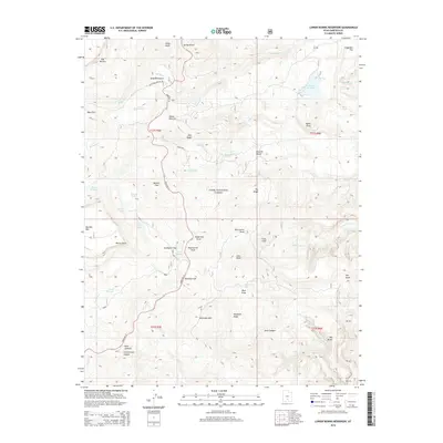
2014 Map of Lower Bowns Reservoir
USGS Topo · Published 2014About this map
Dixie National Forest defines the rugged character of this Garfield County landscape, where the high-altitude terrain of Boulder Mtn drops toward the desert below. A complex network of water management and natural drainage is evident, centered on Bowns Reservoir and the headwaters of Oak Cr. The map reveals the seasonal importance of high-country grazing lands like Wildcat Pasture, Parks Pasture, and Bowery Flat, connected by the winding path of State Rte 12. This 2014 survey documents a wilderness increasingly shaped by both recreational access, such as the Great Western Trl Acc, and vital water resources like Oak Cr Reservoir and the clustered mountain waters of Round Lake, Scout Lake, and Long Lake. The topography is marked by significant elevation changes, from the heights of Big Ridge to the deep incisions of Stair Canyon and Cottonwood Canyon.
Find a feature on this map
57 named features on this map. Tap any name to fly to it.
Don’t see what you’re looking for? This feature index may not catch every label — zoom into the map to look around manually.
Map Details
Editions of this 2014 Lower Bowns Reservoir Map
This is the sole edition of this map. No revisions or reprints were ever made.
Other maps of this area

1885 · Fish Lake
USGS Topo · 1:250,000

1886 · Escalante
USGS Topo · 1:250,000

1896 · Fish Lake
USGS Topo · 1:250,000

1952 · Notom 3 SW
USGS Topo · 1:24,000

1952 · Notom 3 NW
USGS Topo · 1:24,000

1952 · Notom 4 NW
USGS Topo · 1:24,000

1952 · Notom 4 SW
USGS Topo · 1:24,000

1952 · Notom 3 SE
USGS Topo · 1:24,000

1952 · Notom 3 NE
USGS Topo · 1:24,000

1952 · Grover
USGS Topo · 1:62,500