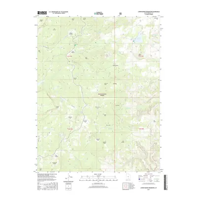
2017 Map of Lower Bowns Reservoir
USGS Topo · Published 2017About this map
Dixie National Forest encompasses this high-altitude landscape in Garfield County, characterized by a complex network of reservoirs and small lakes that support the region's water management. Modern infrastructure like State Rte 12 and the Great Western Trl Acc provide access through the varying elevations of the Boulder Mtn foothills. The terrain is marked by numerous named pastures and flats, such as Wildcat Pasture, Parks Pasture, and Roundup Flat, which suggest a legacy of high-country grazing. Water features are central to the geography here, with Bowns Reservoir and the smaller Oak Cr Reservoir collecting runoff from numerous drainages including Pleasant Cr and Oak Cr. Named topographical markers like Sawmill Bench and Park Ridge define the local ridges and plateaus used by generations of land managers and outdoor enthusiasts.
Find a feature on this map
58 named features on this map. Tap any name to fly to it.
Don’t see what you’re looking for? This feature index may not catch every label — zoom into the map to look around manually.
Map Details
Editions of this 2017 Lower Bowns Reservoir Map
This is the sole edition of this map. No revisions or reprints were ever made.
Other maps of this area

1885 · Fish Lake
USGS Topo · 1:250,000

1886 · Escalante
USGS Topo · 1:250,000

1896 · Fish Lake
USGS Topo · 1:250,000

1952 · Notom 3 SW
USGS Topo · 1:24,000

1952 · Notom 3 NW
USGS Topo · 1:24,000

1952 · Notom 4 NW
USGS Topo · 1:24,000

1952 · Notom 4 SW
USGS Topo · 1:24,000

1952 · Notom 3 SE
USGS Topo · 1:24,000

1952 · Notom 3 NE
USGS Topo · 1:24,000

1952 · Grover
USGS Topo · 1:62,500