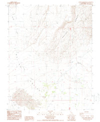
1987 Map of Lower Warm Springs
USGS Topo · Published 1987About this map
Saline Valley dominates this arid Inyo County landscape, where the shifting sands of The Dunes meet the steep slopes of the Saline Range. This 1987 provisional map reveals a remote environment shaped by hydrology and isolation, centered on the vital water source at Lower Warm Springs. Further north, Palm Spring (Hot) and several unnamed Springs provide critical reference points in a desert floor otherwise characterized by ephemeral drainages like Waucoba Wash. Evidence of human activity is sparse but specific, appearing as a Landing Strip and rugged 4wd routes that navigate the valley floor. The map’s focus on geothermal features and natural topography provides an essential record of the region’s extreme geography before modern changes, documenting isolated water sources such as Saline Spring and the complex contouring of the surrounding mountain ranges.
Find a feature on this map
14 named features on this map. Tap any name to fly to it.
Don’t see what you’re looking for? This feature index may not catch every label — zoom into the map to look around manually.
Map Details
Editions of this 1987 Lower Warm Springs Map
This is the sole edition of this map. No revisions or reprints were ever made.
Other maps of this area

1908 · Ballarat
USGS Topo · 1:250,000

1913 · Ballarat
USGS Topo · 1:250,000

1948 · Death Valley
USGS Topo · 1:250,000

1950 · New York Butte
USGS Topo · 1:62,500

1950 · Ubehebe Peak
USGS Topo · 1:62,500

1951 · New York Butte
USGS Topo · 1:62,500

1951 · Ubehebe Peak
USGS Topo · 1:62,500

1951 · Waucoba Wash
USGS Topo · 1:62,500

1954 · Death Valley
USGS Topo · 1:250,000

1956 · Death Valley
USGS Topo · 1:250,000