
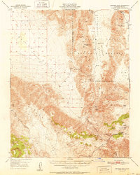
1951 Map of Ubehebe Peak
USGS Topo · Published 1951About this map
Mining operations and geological landmarks define this high-altitude landscape within Death Valley National Monument during the mid-century era. The map details a rugged transition from the Saline Valley (Depression) across the San Nelson Range to the iconic desert basins of the east. Prospectors and geologists of the 1940s and 50s would recognize the density of industrial activity concentrated near Ubehebe Peak, including the Lippincott Lead Mine and the Sally Ann Mine.
Find a feature on this map
32 named features on this map. Tap any name to fly to it.
Don’t see what you’re looking for? This feature index may not catch every label — zoom into the map to look around manually.
Map Details
Editions of this 1951 Ubehebe Peak Map
2 editions found
Other maps of this area

1908 · Ballarat
USGS Topo · 1:250,000

1913 · Ballarat
USGS Topo · 1:250,000

1948 · Death Valley
USGS Topo · 1:250,000

1950 · Darwin
USGS Topo · 1:62,500

1950 · New York Butte
USGS Topo · 1:62,500

1950 · Ubehebe Peak
USGS Topo · 1:62,500

1951 · New York Butte
USGS Topo · 1:62,500

1951 · Darwin
USGS Topo · 1:62,500

1951 · Panamint Butte
USGS Topo · 1:62,500

1951 · Marble Canyon
USGS Topo · 1:62,500