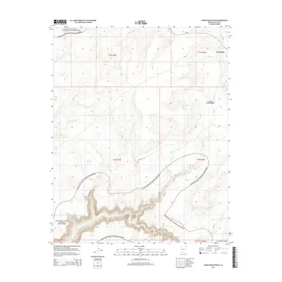
2014 Map of Lower Wheatfields
USGS Topo · Published 2014About this map
Canyon De Chelly National Monument defines the southern and northwestern portions of this landscape, where deep drainages and high plateaus meet. The area is anchored by the community of Wheatfields and its counterpart Lower Wheatfields, situated along the winding course of Wheatfields Cr. This high-altitude terrain on the Defiance Plateau shows a land shaped by water management and natural springs, with Turkey Reservoir, Fish Pond Lake, and Black Pinnacle Spring serving as vital landmarks. The road network, including the Lower Wheatfields Rd and several BIA routes like Bia-12, connects these dispersed settlements. The mapping of Whiskey Cr and Palisade Cr in the southeast corner further illustrates the intricate canyon systems that characterize this part of the Navajo Nation, reflecting a traditional pastoral and residential pattern centered on these seasonal waterways.
Find a feature on this map
20 named features on this map. Tap any name to fly to it.
Don’t see what you’re looking for? This feature index may not catch every label — zoom into the map to look around manually.
Map Details
Editions of this 2014 Lower Wheatfields Map
This is the sole edition of this map. No revisions or reprints were ever made.
Other maps of this area

1892 · Canyon De Chelly
USGS Topo · 1:250,000

1954 · Shiprock
USGS Topo · 1:250,000

1955 · Sonsala Butte 4 SE
USGS Topo · 1:24,000

1955 · Sonsala Butte 4 NW
USGS Topo · 1:24,000

1955 · Sonsala Butte 3 SE
USGS Topo · 1:24,000

1955 · Sonsala Butte 1 SE
USGS Topo · 1:24,000

1955 · Sonsala Butte 2 SE
USGS Topo · 1:24,000
1955 · Sonsala Butte 3 NE
USGS Topo · 1:24,000

1955 · Sonsala Butte 1 SW
USGS Topo · 1:24,000
1955 · Sonsala Butte 4 SW
USGS Topo · 1:24,000
Featured Places
- Chinle Agency, AZ
- Fort Defiance Agency
- Wheatfields, Chinle Agency
- Lower Wheatfields, Chinle Agency
- Apache County, AZ