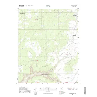
2018 Map of Lower Wheatfields
USGS Topo · Published 2018About this map
Canyon De Chelly National Monument defines the northern and southern reaches of this landscape, where the deeply carved terrain of the Navajo Nation meets the Defiance Plateau. The settlements of Wheatfields and Lower Wheatfields serve as central points for local life, connected by Lower Wheatfields Rd and Indian Rte 9703. Water management is essential in this high-desert environment, evidenced by Turkey Reservoir and the smaller Fish Pond Lake. The map reveals a network of perennial and seasonal water sources, including Wheatfields Cr, Palisade Cr, and Black Pinnacle Spring, which have long sustained grazing and small-scale agriculture in this part of Apache County. This 2018 survey provides a clear look at the modern infrastructure and natural landmarks within the Chinle Agency region.
Find a feature on this map
20 named features on this map. Tap any name to fly to it.
Don’t see what you’re looking for? This feature index may not catch every label — zoom into the map to look around manually.
Map Details
Editions of this 2018 Lower Wheatfields Map
This is the sole edition of this map. No revisions or reprints were ever made.
Other maps of this area

1892 · Canyon De Chelly
USGS Topo · 1:250,000

1954 · Shiprock
USGS Topo · 1:250,000

1955 · Sonsala Butte 4 SE
USGS Topo · 1:24,000

1955 · Sonsala Butte 4 NW
USGS Topo · 1:24,000

1955 · Sonsala Butte 3 SE
USGS Topo · 1:24,000

1955 · Sonsala Butte 1 SE
USGS Topo · 1:24,000

1955 · Sonsala Butte 2 SE
USGS Topo · 1:24,000
1955 · Sonsala Butte 3 NE
USGS Topo · 1:24,000

1955 · Sonsala Butte 1 SW
USGS Topo · 1:24,000
1955 · Sonsala Butte 4 SW
USGS Topo · 1:24,000
Featured Places
- Chinle Agency, AZ
- Fort Defiance Agency
- Wheatfields, Chinle Agency
- Lower Wheatfields, Chinle Agency
- Apache County, AZ