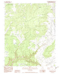
1983 Map of Lower Wheatfields
USGS Topo · Published 1983About this map
Canyon De Chelly National Monument dominates this high-desert landscape within the Navajo Indian Reservation, where dramatic canyon topography meets the pastoral life of the plateau. The settlement of Wheatfields serves as a local hub, anchored by the Wheatfields Chapter House and supported by a complex network of water management features including the Flood Control Ditch and several reservoirs.
Find a feature on this map
16 named features on this map. Tap any name to fly to it.
Don’t see what you’re looking for? This feature index may not catch every label — zoom into the map to look around manually.
Map Details
Editions of this 1983 Lower Wheatfields Map
This is the sole edition of this map. No revisions or reprints were ever made.
Other maps of this area

1892 · Canyon De Chelly
USGS Topo · 1:250,000

1954 · Shiprock
USGS Topo · 1:250,000

1955 · Sonsala Butte 4 SE
USGS Topo · 1:24,000

1955 · Sonsala Butte 4 NW
USGS Topo · 1:24,000

1955 · Sonsala Butte 3 SE
USGS Topo · 1:24,000

1955 · Sonsala Butte 1 SE
USGS Topo · 1:24,000

1955 · Sonsala Butte 2 SE
USGS Topo · 1:24,000
1955 · Sonsala Butte 3 NE
USGS Topo · 1:24,000

1955 · Sonsala Butte 1 SW
USGS Topo · 1:24,000
1955 · Sonsala Butte 4 SW
USGS Topo · 1:24,000
Featured Places
- Chinle Agency, AZ
- Fort Defiance Agency
- Wheatfields, Chinle Agency
- Lower Wheatfields, Chinle Agency
- Apache County, AZ