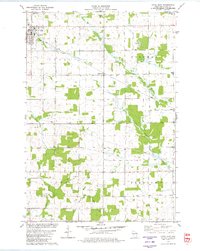
1979 Map of Loyal East
USGS Topo · Published 1980About this map
Dairy farming and timber processing roots are evident across this central Wisconsin landscape, where the city of Loyal serves as the primary hub along the Soo Line tracks. The map details a transition from the active rail corridor in the west to the winding drainage of the South Branch Yellow River and Rock Creek in the east. Small unincorporated settlements like Spokeville and Veefkind anchor the rural townships, surrounded by an extensive network of drainage creeks including O'Neill Creek and its various branches. Genealogists will find several burial grounds mapped, such as St Anthony Cem and York Center Cem. Industrial activity is marked by various Gravel Pits and Sandpits, while the presence of an Old Railroad Grade in the south provides a physical record of the evolving transportation infrastructure in Clark County during the late 1970s.
Find a feature on this map
23 named features on this map. Tap any name to fly to it.
Don’t see what you’re looking for? This feature index may not catch every label — zoom into the map to look around manually.
Map Details
Editions of this 1979 Loyal East Map
This is the sole edition of this map. No revisions or reprints were ever made.
Other maps of this area

1953 · Neillsville
USGS Topo · 1:62,500

1953 · Abbotsford
USGS Topo · 1:48,000

1953 · Owen
USGS Topo · 1:48,000

1953 · Eau Claire
USGS Topo · 1:250,000

1954 · Granton
USGS Topo · 1:62,500

1958 · Eau Claire
USGS Topo · 1:250,000

1963 · Abbotsford
USGS Topo · 1:62,500

1963 · Owen
USGS Topo · 1:62,500

1964 · Eau Claire
USGS Topo · 1:250,000
1979 · Lindsey
USGS Topo · 1:24,000