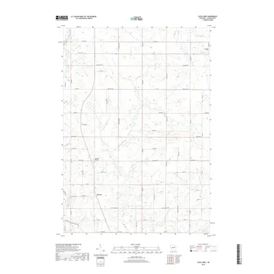
2018 Map of Loyal West
USGS Topo · Published 2018About this map
Dairy farming country in Clark County defines the landscape surrounding Christie, where the Black River winds along the western edge of the quadrangle. The terrain is marked by gentle elevations like Christie Mound and a dense network of country roads named for local families and wildlife, including Suckow Rd and Bobwhite Rd. To the northeast, the outskirts of Loyal appear, connected to the southern settlements by a grid of agricultural corridors such as Fairground Ave and Owen Ave. Numerous small waterways, including Cawley Cr and Panther Cr, drain the fields and woodlands, while East Side Cem provides a point of interest for those tracing local family roots in this rural Wisconsin interior.
Find a feature on this map
44 named features on this map. Tap any name to fly to it.
Don’t see what you’re looking for? This feature index may not catch every label — zoom into the map to look around manually.
Map Details
Editions of this 2018 Loyal West Map
This is the sole edition of this map. No revisions or reprints were ever made.
Other maps of this area

1953 · Neillsville
USGS Topo · 1:62,500

1953 · Abbotsford
USGS Topo · 1:48,000

1953 · Owen
USGS Topo · 1:48,000

1953 · Eau Claire
USGS Topo · 1:250,000

1954 · Granton
USGS Topo · 1:62,500

1958 · Eau Claire
USGS Topo · 1:250,000

1963 · Abbotsford
USGS Topo · 1:62,500

1963 · Owen
USGS Topo · 1:62,500

1964 · Eau Claire
USGS Topo · 1:250,000
1979 · Granton
USGS Topo · 1:24,000