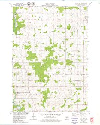
1979 Map of Loyal West
USGS Topo · Published 1980About this map
The Black River defines the western edge of this Clark County landscape, where dairy farming and rural townships intersect. Mapping of the late 1970s reveals a structured agricultural grid divided into Eaton, Loyal, Weston, and York townships. The topography is punctuated by Christie Mound, a significant elevation in an otherwise gently undulating terrain drained by Cawley Creek and Bear Creek. Local genealogy and community history are anchored by small religious and burial sites, including the Marie Louise Chapel and several burial grounds such as East Side Cem and Free Cem. The settlement of Christie and the western outskirts of Loyal show a sparse but persistent rural footprint, supported by local infrastructure like the Radio Tower and numerous gravel extractions along the riverbanks.
Find a feature on this map
21 named features on this map. Tap any name to fly to it.
Don’t see what you’re looking for? This feature index may not catch every label — zoom into the map to look around manually.
Map Details
Editions of this 1979 Loyal West Map
This is the sole edition of this map. No revisions or reprints were ever made.
Other maps of this area

1953 · Neillsville
USGS Topo · 1:62,500

1953 · Abbotsford
USGS Topo · 1:48,000

1953 · Owen
USGS Topo · 1:48,000

1953 · Eau Claire
USGS Topo · 1:250,000

1954 · Granton
USGS Topo · 1:62,500

1958 · Eau Claire
USGS Topo · 1:250,000

1963 · Abbotsford
USGS Topo · 1:62,500

1963 · Owen
USGS Topo · 1:62,500

1964 · Eau Claire
USGS Topo · 1:250,000
1979 · Granton
USGS Topo · 1:24,000