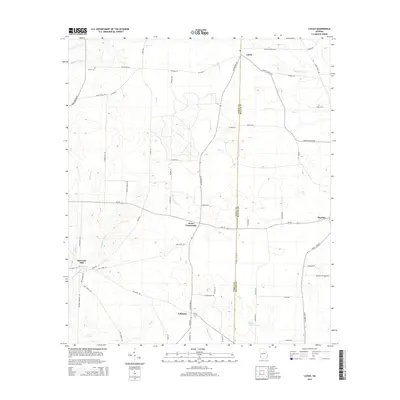
2014 Map of Lucile
USGS Topo · Published 2014About this map
Lucile and Jones Crossroads anchor this rural landscape in Southwest Georgia, where the boundary between Early and Miller counties is defined by Early Co Line Rd. The terrain is shaped by a dense network of slow-moving waterways, including Acocks Cr, Flat Cr, and Sheffield Mill Cr, which converge as they drain toward the south. The prevalence of named mill creeks and the presence of Howards Mill suggest a history of localized water-powered industry that once supported these agricultural communities.
Find a feature on this map
61 named features on this map. Tap any name to fly to it.
Don’t see what you’re looking for? This feature index may not catch every label — zoom into the map to look around manually.
Map Details
Editions of this 2014 Lucile Map
This is the sole edition of this map. No revisions or reprints were ever made.
Other maps of this area

1953 · Dothan
USGS Topo · 1:250,000

1954 · Dothan
USGS Topo · 1:250,000

1955 · Dothan
USGS Topo · 1:250,000

1970 · Gordon
USGS Topo · 1:24,000
1970 · Saffold
USGS Topo · 1:24,000

1970 · Columbia
USGS Topo · 1:24,000

1973 · Blakely South
USGS Topo · 1:24,000

1973 · Hentown
USGS Topo · 1:24,000

1974 · Donalsonville NE
USGS Topo · 1:24,000
1974 · Donalsonville East
USGS Topo · 1:24,000