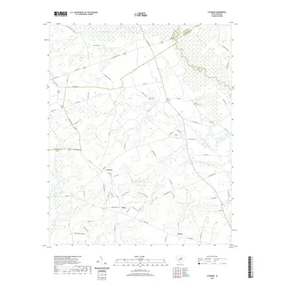
2020 Map of Lucknow
USGS Topo · Published 2020About this map
Lucknow sits at the heart of this South Carolina landscape, where the flatlands of Lee County meet the winding drainages of the Lynches River and Little Lynches River. The terrain is defined by a series of creeks and millponds, such as Halls Millpond and Merchants Mill Cr, which hint at the region's agricultural and milling heritage. The map documents a rural network of named settlements including Zemp and Thursa, alongside several early cemeteries like Bethany Cem and Turkey Creek Cem that serve as vital anchors for genealogical research. Strategic crossing points, most notably Tillers Bridge, connect the intricate web of county roads that traverse the county lines of Chesterfield, Darlington, and Kershaw. This survey illustrates how the local economy remains tied to the water, with features like Sunesac Lake and Newson Pond dotting the low-lying areas between the ridges.
Find a feature on this map
78 named features on this map. Tap any name to fly to it.
Don’t see what you’re looking for? This feature index may not catch every label — zoom into the map to look around manually.
Map Details
Editions of this 2020 Lucknow Map
This is the sole edition of this map. No revisions or reprints were ever made.
Other maps of this area

1941 · Spartanburg
USGS Topo · 1:250,000

1953 · Spartanburg
USGS Topo · 1:250,000

1957 · Ashwood
USGS Topo · 1:62,500

1960 · Spartanburg
USGS Topo · 1:250,000

1963 · Spartanburg
USGS Topo · 1:250,000

1964 · Spartanburg
USGS Topo · 1:250,000
1968 · Lake Robinson
USGS Topo · 1:24,000

1968 · Kellytown
USGS Topo · 1:24,000
1969 · Bishopville East
USGS Topo · 1:24,000
1970 · Cassatt
USGS Topo · 1:24,000