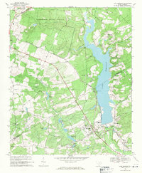
1968 Map of Lake Robinson
USGS Topo · Published 1971About this map
Lake Robinson dominates the eastern half of this landscape, its waters contained by a dam and Powerplant at the southern end. This mid-century survey illustrates a region defined by extensive timberlands and conservation areas, notably the Sandhills State Forest and the Carolina Sandhills National Wildlife Refuge. The terrain is marked by numerous water bodies and drainage systems, including Beaverdam Creek and Black Creek, which feed into the central reservoir. The infrastructure of the era is evident in the presence of the Seaboard Coast Line railroad, which cuts diagonally across the forest, and a major Pipeline corridor crossing the southern reaches.
Find a feature on this map
36 named features on this map. Tap any name to fly to it.
Don’t see what you’re looking for? This feature index may not catch every label — zoom into the map to look around manually.
Map Details
Editions of this 1968 Lake Robinson Map
2 editions found
Other maps of this area

1941 · Spartanburg
USGS Topo · 1:250,000

1953 · Spartanburg
USGS Topo · 1:250,000

1960 · Spartanburg
USGS Topo · 1:250,000

1963 · Spartanburg
USGS Topo · 1:250,000

1964 · Spartanburg
USGS Topo · 1:250,000

1967 · Angelus
USGS Topo · 1:24,000

1968 · Patrick
USGS Topo · 1:24,000

1968 · Middendorf
USGS Topo · 1:24,000
1968 · Hartsville North
USGS Topo · 1:24,000

1968 · Kellytown
USGS Topo · 1:24,000