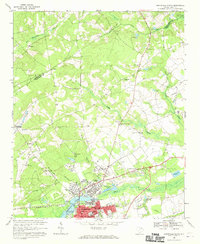
1968 Map of Hartsville North
USGS Topo · Published 1970About this map
Hartsville and its northern suburbs are the focal point of this late 1960s topographic study, illustrating the community's expansion between the Seaboard Coast Line railroad and the waters of Black Creek. The city's institutional core is clearly defined, featuring the Coker College campus, St Marys Sch, and Byerly Hospital. Beyond the residential blocks of Lakeside and North Hartsville, the landscape transitions into a mix of timberland and agriculture, notably bounded by the Sandhills State Forest to the north.
Find a feature on this map
59 named features on this map. Tap any name to fly to it.
Don’t see what you’re looking for? This feature index may not catch every label — zoom into the map to look around manually.
Map Details
Editions of this 1968 Hartsville North Map
This is the sole edition of this map. No revisions or reprints were ever made.
Other maps of this area

1941 · Spartanburg
USGS Topo · 1:250,000

1942 · Rockingham
USGS Topo · 1:125,000

1953 · Florence
USGS Topo · 1:250,000

1953 · Spartanburg
USGS Topo · 1:250,000

1954 · Florence
USGS Topo · 1:250,000

1960 · Spartanburg
USGS Topo · 1:250,000

1963 · Spartanburg
USGS Topo · 1:250,000

1963 · Dovesville
USGS Topo · 1:24,000

1963 · Darlington West
USGS Topo · 1:24,000

1964 · Spartanburg
USGS Topo · 1:250,000