
1963 Map of Darlington West
USGS Topo · Published 1965About this map
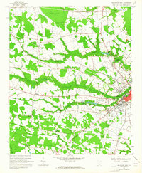
Darlington serves as the focal point of this mid-century coastal plain landscape, where the town’s edge transitions into a network of agriculture and industry. The presence of the iconic Darlington Raceway and the Moore Airport signals the region's modernization, even as traditional landmarks like McCowns Millpond and the County Prison Camp anchor its social history. The terrain is defined by low-lying watercourses including Bellyache Creek and Swift Creek, which meander through the Cypress Flat and several Carolina bays, shown here as elliptical blue outlines.
Find a feature on this map
60 named features on this map. Tap any name to fly to it.
Don’t see what you’re looking for? This feature index may not catch every label — zoom into the map to look around manually.
Map Details
Editions of this 1963 Darlington West Map
2 editions found
Other maps of this area

1940 · Florence West
USGS Topo · 1:62,500

1941 · Spartanburg
USGS Topo · 1:250,000

1945 · Florence West
USGS Topo · 1:62,500

1953 · Florence
USGS Topo · 1:250,000

1953 · Spartanburg
USGS Topo · 1:250,000

1954 · Florence
USGS Topo · 1:250,000

1960 · Spartanburg
USGS Topo · 1:250,000

1963 · Spartanburg
USGS Topo · 1:250,000

1963 · Dovesville
USGS Topo · 1:24,000

1963 · Mont Clare
USGS Topo · 1:24,000