1968 Map of Lake Robinson
USGS Topo · Published 1991About this map
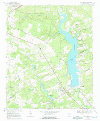
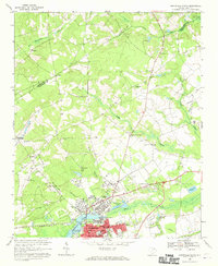
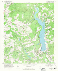
Lake Robinson dominates the eastern half of this landscape, its waters contained by a southern dam near the powerplant and gaging station. This 1960s survey illustrates a rural South Carolina corridor defined by the Seaboard Coast Line railroad and numerous water-powered millponds. The topography transitions from the protected lands of the Carolina Sandhills National Wildlife Refuge and Sandhills State Forest in the northwest toward the settled areas of McBee and Clyde. Genealogists will find a high density of rural houses of worship, including Tabernacle Ch, Shady Grove Ch, and Antioch Ch, alongside family landmarks like McLean Cem. The presence of several claypits and a major pipeline corridor reflects the local industrial footprint during this era of development.
Find a feature on this map
39 named features on this map. Tap any name to fly to it.
Don’t see what you’re looking for? This feature index may not catch every label — zoom into the map to look around manually.
Map Details
Editions of this 1968 Lake Robinson Map
2 editions found
Other maps of this area

1941 · Spartanburg
USGS Topo · 1:250,000

1953 · Spartanburg
USGS Topo · 1:250,000

1960 · Spartanburg
USGS Topo · 1:250,000

1963 · Spartanburg
USGS Topo · 1:250,000

1964 · Spartanburg
USGS Topo · 1:250,000
1967 · Angelus
USGS Topo · 1:24,000
1968 · Patrick
USGS Topo · 1:24,000
1968 · Middendorf
USGS Topo · 1:24,000
1968 · Hartsville North
USGS Topo · 1:24,000
1968 · Lake Robinson
USGS Topo · 1:24,000