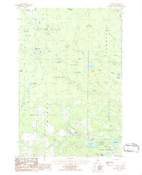
1986 Map of Ludlow
USGS Topo · Published 1986About this map
Smyrna Center and Ludlow anchor this landscape of the Maine North Woods during the mid-1980s, an era defined by timber management and small-town agriculture. The terrain is a network of ridges and water bodies, where timber resources are evidenced by several Gravel Pits and a complex drainage system including Thousand Acre Swamp and Cameron Bog. The geography of the Smyrna and Ludlow townships is deeply etched by glacial movement, creating numerous small basins like Half Moon Pond, Duck Pond, and Cochrane Lake.
Find a feature on this map
42 named features on this map. Tap any name to fly to it.
Don’t see what you’re looking for? This feature index may not catch every label — zoom into the map to look around manually.
Map Details
Editions of this 1986 Ludlow Map
2 editions found
Other maps of this area

1934 · Bridgewater
USGS Topo · 1:48,000

1935 · Howe Brook
USGS Topo · 1:48,000

1937 · Smyrna Mills
USGS Topo · 1:62,500

1938 · Bridgewater
USGS Topo · 1:62,500

1938 · Houlton
USGS Topo · 1:62,500

1939 · Howe Brook
USGS Topo · 1:62,500

1951 · Houlton
USGS Topo · 1:62,500

1951 · Bridgewater
USGS Topo · 1:62,500

1953 · Bridgewater
USGS Topo · 1:50,000

1954 · Howe Brook
USGS Topo · 1:62,500