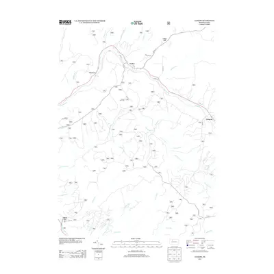
2013 Map of Ludlow
USGS Topo · Published 2013About this map
Ludlow serves as a primary settlement node in this corner of Warren County, positioned along the winding course of Twomile Run. The landscape is defined by its dense network of waterways, including the E Br Tionesta Cr and numerous tributary runs like Pigeon Run and Roystone Run. Settlement is concentrated along the east-west corridor following the valley, where Roystone and Wetmore are connected by the thoroughfare of Water St and Olmsted Rd. Higher elevations are marked by Gibbs Hill and the presence of the Sheffield Lookout Tower, indicating the importance of forest monitoring in this heavily wooded region. Local landmarks like Hoffman Farm Camp and roads such as Gibbs Hill Rd reflect a history of timber management and rural land use within the Allegheny National Forest vicinity.
Find a feature on this map
30 named features on this map. Tap any name to fly to it.
Don’t see what you’re looking for? This feature index may not catch every label — zoom into the map to look around manually.
Map Details
Editions of this 2013 Ludlow Map
This is the sole edition of this map. No revisions or reprints were ever made.
Other maps of this area

1906 · Warren
USGS Topo · 1:62,500

1907 · Warren
USGS Topo · 1:62,500

1908 · Warren
USGS Topo · 1:62,500

1934 · Kane
USGS Topo · 1:48,000

1935 · Sheffield
USGS Topo · 1:48,000

1936 · Kinzua
USGS Topo · 1:48,000

1939 · Kane
USGS Topo · 1:62,500

1941 · Sheffield
USGS Topo · 1:62,500

1941 · Kinzua
USGS Topo · 1:62,500
1949 · Kinzua
USGS Topo · 1:62,500
Featured Places
- Sheffield Township, PA
- Wetmore, Hamilton Township
- Wetmore Township, PA
- Hamilton Township, PA
- Gibbs Hill, Hamilton Township