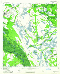
1943 Map of Ludowici
USGS Topo · Published 1964About this map
Ludowici serves as the primary junction in this coastal Georgia region, where the Atlantic Coast Line and Seaboard Air Line railroads converge amidst a landscape of dense swamps and river bottoms. The map documents the intricate hydrology of the Altamaha River floodplain, noting specific navigational hazards such as the Wreck of Louise and the location where overflow occurs at this point. Small agricultural and timber settlements like Walthourville, Bobtown, and Tibet are scattered between the river and the northern marshes, connected by the historic Darien Road. Along the riverbanks, numerous oxbow lakes and bights are named, including Middleton Lakes and Old Hill Bight, reflecting a landscape deeply shaped by seasonal flooding. The presence of several scattered Art Well locations suggests the importance of groundwater for these rural communities and local industry during the early 1940s.
Find a feature on this map
27 named features on this map. Tap any name to fly to it.
Don’t see what you’re looking for? This feature index may not catch every label — zoom into the map to look around manually.
Map Details
Editions of this 1943 Ludowici Map
4 editions found
Other maps of this area

1918 · Jesup
USGS Topo · 1:62,500

1918 · Hortense
USGS Topo · 1:62,500

1918 · Hinesville
USGS Topo · 1:62,500

1918 · Everett City
USGS Topo · 1:62,500

1920 · Glennville
USGS Topo · 1:62,500

1920 · Sapelo River
USGS Topo · 1:62,500

1920 · Limerick
USGS Topo · 1:62,500

1920 · Everett City
USGS Topo · 1:62,500

1921 · Darien
USGS Topo · 1:62,500

1943 · Ludowici
USGS Topo · 1:62,500