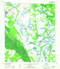
1943 Map of Ludowici
USGS Topo · Published 1965About this map
Ludowici stands as a rail junction in the early 1940s, where the Atlantic Coast Line and Seaboard Line converge near the edge of the coastal wetlands. The landscape is dominated by the complex hydrology of the Altamaha River basin, characterized by a dense network of sloughs and lakes such as Old Hell Bight and Sister Pine Lake. This survey, compiled from 1942 aerial photography, captures a transitional era for the region's transport, showing the enduring importance of river geography alongside established thoroughfares like Darien Road.
Find a feature on this map
31 named features on this map. Tap any name to fly to it.
Don’t see what you’re looking for? This feature index may not catch every label — zoom into the map to look around manually.
Map Details
Editions of this 1943 Ludowici Map
4 editions found
Other maps of this area

1918 · Jesup
USGS Topo · 1:62,500

1918 · Hortense
USGS Topo · 1:62,500

1918 · Hinesville
USGS Topo · 1:62,500

1918 · Everett City
USGS Topo · 1:62,500

1920 · Glennville
USGS Topo · 1:62,500

1920 · Sapelo River
USGS Topo · 1:62,500

1920 · Limerick
USGS Topo · 1:62,500

1920 · Everett City
USGS Topo · 1:62,500

1921 · Darien
USGS Topo · 1:62,500

1943 · Ludowici
USGS Topo · 1:62,500