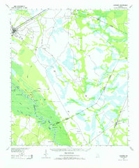
1943 Map of Ludowici
USGS Topo · Published 1965About this map
Altamaha River bottomlands dominate the southern landscape of this 1940s survey, where the river's meandering course creates a complex network of sloughs and islands. The cartography reveals a transition from the agricultural and rail hubs of Ludowici and Walthourville into the dense cypress and tupelo environments of Holloway Swamp and Joyner Island. Along the riverbanks, curious landmarks such as the Wreck of Louise and Bug Bluff suggest the historical importance of the waterway before the shifting channels of the Phin River (Old R) and Miller Lake Cutoff altered navigation. The rail infrastructure is clearly defined, with the Atlantic Coast Line and Seaboard Air Line cutting through the coastal plain. Scattered settlements like Tibet, Bobtown, and Upper Sensavilla appear as small rural outposts, many connected by the established King Road and Darien Road.
Find a feature on this map
35 named features on this map. Tap any name to fly to it.
Don’t see what you’re looking for? This feature index may not catch every label — zoom into the map to look around manually.
Map Details
Editions of this 1943 Ludowici Map
4 editions found
Other maps of this area

1918 · Jesup
USGS Topo · 1:62,500

1918 · Hortense
USGS Topo · 1:62,500

1918 · Hinesville
USGS Topo · 1:62,500

1918 · Everett City
USGS Topo · 1:62,500

1920 · Glennville
USGS Topo · 1:62,500

1920 · Sapelo River
USGS Topo · 1:62,500

1920 · Limerick
USGS Topo · 1:62,500

1920 · Everett City
USGS Topo · 1:62,500

1921 · Darien
USGS Topo · 1:62,500

1943 · Ludowici
USGS Topo · 1:62,500