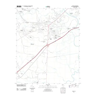
2011 Map of Lugoff
USGS Topo · Published 2011About this map
Lugoff serves as the primary residential and commercial hub in this Kershaw County landscape, characterized by numerous small named neighborhoods and subdivisions that reflect its suburban growth. Just north of Interstate 70, residential pockets like Mayfield Acres, Pepper Ridge, and Spring Village fill the spaces between the watercourses. To the south, the terrain opens into broader hydrological features, dominated by the winding path of Gum Swamp and the southern reaches of Haig Creek. Local history is anchored by Saint Pauls Cemetery and Porter Cemetery near the southwestern edge of the quadrangle.
Find a feature on this map
123 named features on this map. Tap any name to fly to it.
Don’t see what you’re looking for? This feature index may not catch every label — zoom into the map to look around manually.
Map Details
Editions of this 2011 Lugoff Map
This is the sole edition of this map. No revisions or reprints were ever made.
Other maps of this area

1935 · Camden
USGS Topo · 1:48,000

1935 · Killian
USGS Topo · 1:48,000

1937 · Killian
USGS Topo · 1:62,500

1938 · Camden
USGS Topo · 1:62,500

1938 · Hagood
USGS Topo · 1:62,500

1941 · Spartanburg
USGS Topo · 1:250,000

1942 · Camden
USGS Topo · 1:125,000

1953 · Camden South
USGS Topo · 1:24,000

1953 · Messers Pond
USGS Topo · 1:24,000

1953 · Lugoff
USGS Topo · 1:24,000