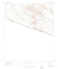
1963 Map of Lukeville
USGS Topo · Published 1974About this map
The international border between the United States and Mexico dominates this desert landscape, anchored by the Lukeville Port of Entry Immigration and Customs at the southern terminus of the regional highway system. Most of the territory falls within the Organ Pipe Cactus National Monument, where the environment transitions from the broad La Abra Plain into the sharp rises of the Puerto Blanco Mountains. This era shows the developed infrastructure for the monument, including the Monument Headquarters, a Campground, and scenic routes like Puerto Blanco Drive. Evidence of earlier resource extraction persists in the form of the Victoria Mine, Baker Mine, and the Lost Cabin Mine. Smaller settlements and outposts like Lukeville, Dos Lomitas, and Dowling Ranch mark the limited human habitation in the arid Sonoyta Valley, while essential water sources are noted at Red Tanks Well and Poro Salado Well.
Find a feature on this map
33 named features on this map. Tap any name to fly to it.
Don’t see what you’re looking for? This feature index may not catch every label — zoom into the map to look around manually.
Map Details
Editions of this 1963 Lukeville Map
2 editions found
Other maps of this area

1953 · Ajo
USGS Topo · 1:250,000

1954 · Sonoyta
USGS Topo · 1:250,000

1957 · Ajo
USGS Topo · 1:250,000

1958 · Ajo
USGS Topo · 1:250,000

1962 · Ajo
USGS Topo · 1:250,000

1963 · Ajo
USGS Topo · 1:250,000

1963 · Mt. Ajo
USGS Topo · 1:62,500

1963 · Lukeville
USGS Topo · 1:62,500

1963 · Quitobaquito Springs
USGS Topo · 1:62,500

1963 · Kino Peak
USGS Topo · 1:62,500