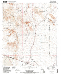
1996 Map of Lukeville
USGS Topo · Published 2000About this map
The United States of America Estados Unidos Mexicanos international border defines the character of this 1990s landscape, centered on the crossing at Lukeville. The survey shows the transition from the rugged Puerto Blanco Mountains and the Senita Basin into the broad Sonoyta Valley. Within the Organ Pipe Cactus National Monument, the map preserves the locations of early mining efforts, including the Victoria Mine, Baker Mine, and Lost Cabin Mine, as well as several smaller prospects. A network of historic paths like the Lost Cabin Trail and Martinez Victoria Trail crisscross the wilderness area, leading to landmarks like the Monument Visitors Center and the Port of Entry. Further south, the map includes details of Sonoyta (Aduana) across the Arizona-Sonora line.
Find a feature on this map
52 named features on this map. Tap any name to fly to it.
Don’t see what you’re looking for? This feature index may not catch every label — zoom into the map to look around manually.
Map Details
Editions of this 1996 Lukeville Map
This is the sole edition of this map. No revisions or reprints were ever made.
Other maps of this area

1953 · Ajo
USGS Topo · 1:250,000

1954 · Sonoyta
USGS Topo · 1:250,000

1957 · Ajo
USGS Topo · 1:250,000

1958 · Ajo
USGS Topo · 1:250,000

1962 · Ajo
USGS Topo · 1:250,000

1963 · Ajo
USGS Topo · 1:250,000

1963 · Mt. Ajo
USGS Topo · 1:62,500

1963 · Lukeville
USGS Topo · 1:62,500

1963 · Kino Peak
USGS Topo · 1:62,500

1963 · Lukeville
USGS Topo · 1:250,000