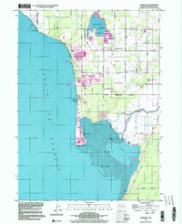
1997 Map of Lummi Bay
USGS Topo · Published 2003About this map
Lummi Bay and the adjacent Strait of Georgia dominate this coastal landscape in Whatcom County, where heavy industry meets indigenous lands. The northern shoreline is defined by the massive infrastructure of an Aluminum Plant and a large Refinery, complete with their associated industrial waste ponds and piers reaching into the strait. These industrial facilities sit just north of the Lummi Indian Reservation Boundary, illustrating the complex land-use patterns of the late twentieth century. Inland, the State Wildlife Area surrounding Lake Terrell provides a contrast to the coastal developments.
Find a feature on this map
38 named features on this map. Tap any name to fly to it.
Don’t see what you’re looking for? This feature index may not catch every label — zoom into the map to look around manually.
Map Details
Editions of this 1997 Lummi Bay Map
This is the sole edition of this map. No revisions or reprints were ever made.
Other maps of this area

1907 · Blaine
USGS Topo · 1:62,500

1943 · Orcas Island
USGS Topo · 1:62,500

1943 · Anacortes
USGS Topo · 1:62,500

1951 · Anacortes
USGS Topo · 1:62,500

1952 · Bertrand Creek
USGS Topo · 1:24,000

1952 · Birch Point
USGS Topo · 1:24,000

1952 · Ferndale
USGS Topo · 1:24,000

1952 · Lummi Bay
USGS Topo · 1:24,000

1952 · Blaine
USGS Topo · 1:24,000

1952 · Blaine
USGS Topo · 1:62,500