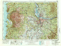
1958 Map of Vancouver
USGS Topo · Published 1976About this map
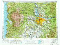
Portland and Vancouver dominate the confluence of the Willamette River and Columbia River, serving as the central urban hub in this mid-1970s revision of a 1950s survey. The map reveals the intricate water network of the Tualatin River valley and the industrial importance of Sauvie Island at the river junction. Moving west toward the Pacific Ocean, the landscape shifts into the dense timberlands of the Coast Range and the high peaks of Saddle Mountain, eventually reaching coastal settlements like Seaside, Cannon Beach, and Tillamook. This era captures the region's post-war suburban expansion, with developed clusters in Beaverton, Hillsboro, and Gresham appearing alongside long-established timber and agricultural corridors. The presence of the S P & S Ry and S P Ry railroads underscores the vital transportation links between the coast, the valley, and the expanding metropolitan core.
Find a feature on this map
111 named features on this map. Tap any name to fly to it.
Don’t see what you’re looking for? This feature index may not catch every label — zoom into the map to look around manually.
Map Details
Editions of this 1958 Vancouver Map
3 editions found

Other maps of this area

1897 · Portland
USGS Topo · 1:62,500

1905 · Portland
USGS Topo · 1:62,500

1911 · Boring
USGS Topo · 1:48,000

1914 · Boring
USGS Topo · 1:62,500

1914 · Oregon City
USGS Topo · 1:62,500

1915 · Rickreall
USGS Topo · 1:31,680

1915 · Hillsboro
USGS Topo · 1:62,500

1915 · Eola
USGS Topo · 1:31,680

1916 · Tualatin
USGS Topo · 1:62,500

1916 · Estacada
USGS Topo · 1:125,000