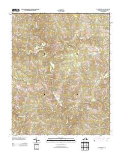
2013 Map of Lunenburg
USGS Topo · Published 2013About this map
The N Meherrin River and its numerous tributaries, including Hurricane Cr and Lyle Cr, define the drainage of this central Virginia landscape. In the early 21st century, the area remains characterized by a network of rural routes connecting small, established settlements. The community of Lunenburg serves as a focal point in the northeast, while Rehoboth and Loves Mill anchor the southern and western portions of the quadrangle. Many roads, such as Wilson Farm Rd, Crymes Rd, and Sheltons Rd, reflect long-standing family associations with the land. The presence of Saint Johns Cr and the Middle Meherrin River in the southwest suggests a terrain heavily influenced by the meandering waterways that have shaped local property lines and agricultural patterns for generations.
Find a feature on this map
53 named features on this map. Tap any name to fly to it.
Don’t see what you’re looking for? This feature index may not catch every label — zoom into the map to look around manually.
Map Details
Editions of this 2013 Lunenburg Map
This is the sole edition of this map. No revisions or reprints were ever made.
Other maps of this area

1891 · Farmville
USGS Topo · 1:125,000

1893 · Farmville
USGS Topo · 1:125,000

1947 · Roanoke
USGS Topo · 1:250,000

1953 · Greensboro
USGS Topo · 1:250,000

1954 · Greensboro
USGS Topo · 1:250,000

1955 · Chase City
USGS Topo · 1:62,500

1955 · Kenbridge
USGS Topo · 1:62,500

1958 · Crewe
USGS Topo · 1:62,500

1958 · Keysville
USGS Topo · 1:62,500

1959 · Roanoke
USGS Topo · 1:250,000