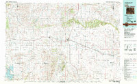
1982 Map of Lusk
USGS Topo · Published 1983About this map
The Chicago and North Western railroad corridor dictates the settlement pattern of this high plains region in the early 1980s, anchoring towns like Lusk, Manville, and Node along a central east-west axis. The landscape is defined by massive drainage systems and topographical breaks, including the Hat Creek Breaks to the north and the complex draws leading toward the Niobrara River. To the southwest, the North Platte River feeds into the Glendo Reservoir within Glendo State Park, providing a sharp contrast to the surrounding ranching and dryland terrain. Historical connectivity is evident in smaller outposts such as Van Tassell on the Nebraska border and Lost Springs to the west. Landmarks like Steamboat Rock, Chimney Rock, and the Seaman Hills provide essential navigational points across the expansive plains of Niobrara and Converse counties.
Find a feature on this map
62 named features on this map. Tap any name to fly to it.
Don’t see what you’re looking for? This feature index may not catch every label — zoom into the map to look around manually.
Map Details
Editions of this 1982 Lusk Map
This is the sole edition of this map. No revisions or reprints were ever made.
Other maps of this area

1896 · Patrick
USGS Topo · 1:125,000

1896 · Hartville
USGS Topo · 1:125,000

1899 · Whistle Creek
USGS Topo · 1:125,000

1901 · Hartville
USGS Topo · 1:125,000

1902 · Edgemont
USGS Topo · 1:125,000

1949 · Shawnee
USGS Topo · 1:24,000

1949 · Cedar Top
USGS Topo · 1:24,000

1950 · Glendo
USGS Topo · 1:24,000

1950 · Amend Ranch
USGS Topo · 1:24,000

1950 · Cedar Top
USGS Topo · 1:24,000