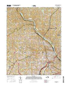
2016 Map of Lynchburg
USGS Topo · Published 2016About this map
The James River defines the geography of this mid-2010s survey, winding between Madison Heights and the central city of Lynchburg. The map reveals a landscape densely packed with institutional and civic history, from Randolph Coll and Lynchburg Coll to the sprawling grounds of the Virginia Univ of Lynchburg. Genealogists will find a concentration of significant burial grounds, including the Old City Cem, Spring Hill Cem, and Presbyterian Cem, which reflect the city's long-established residential patterns. The river itself is punctuated by major crossings such as the Carter Glass Bridge and a series of islands like Treasure Island and Percivals Island. To the west, the transition from urban neighborhoods like Dearington and Fort Hill into the suburbs of Blue Ridge Farms and Forest Hill illustrates the modern footprint of this regional hub.
Find a feature on this map
56 named features on this map. Tap any name to fly to it.
Don’t see what you’re looking for? This feature index may not catch every label — zoom into the map to look around manually.
Map Details
Editions of this 2016 Lynchburg Map
This is the sole edition of this map. No revisions or reprints were ever made.
Other maps of this area

1892 · Lynchburg
USGS Topo · 1:125,000

1894 · Lexington
USGS Topo · 1:125,000

1935 · Buena Vista
USGS Topo · 1:48,000

1935 · Amherst
USGS Topo · 1:48,000

1939 · Amherst
USGS Topo · 1:62,500

1939 · Buena Vista
USGS Topo · 1:62,500

1940 · Buena Vista
USGS Topo · 1:62,500

1944 · Lynchburg
USGS Topo · 1:62,500

1947 · Roanoke
USGS Topo · 1:250,000

1950 · Goode
USGS Topo · 1:62,500