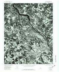
1977 Map of Lynchburg
USGS Topo · Published 1983About this map
Lynchburg and its northern surroundings appear here in sharp relief, captured by the U.S. Geological Survey using 1977 aerial photography. The imagery reveals the dense urban grid of the city concentrated south of the wide bend in the James River, contrasting with the more dispersed residential patterns in Peakland and Blue Ridge Farms. This orthophotoquad provides an unvarnished look at the landscape's transformation in the late 1970s, where traditional watercourses like Blackwater Creek and Ivy Creek dictated the expansion of neighborhoods and infrastructure. To the north, the settlement of Monroe sits near the winding path of Harris Creek, showing the rural-to-suburban transition of the era. The map serves as a primary source for understanding the mid-century footprint of the region, documenting the precise location of every building and road as they existed before further modern development.
Find a feature on this map
8 named features on this map. Tap any name to fly to it.
Don’t see what you’re looking for? This feature index may not catch every label — zoom into the map to look around manually.
Map Details
Editions of this 1977 Lynchburg Map
This is the sole edition of this map. No revisions or reprints were ever made.
Other maps of this area

1892 · Lynchburg
USGS Topo · 1:125,000

1894 · Lexington
USGS Topo · 1:125,000

1935 · Buena Vista
USGS Topo · 1:48,000

1935 · Amherst
USGS Topo · 1:48,000

1939 · Amherst
USGS Topo · 1:62,500

1939 · Buena Vista
USGS Topo · 1:62,500

1940 · Buena Vista
USGS Topo · 1:62,500

1944 · Lynchburg
USGS Topo · 1:62,500

1947 · Roanoke
USGS Topo · 1:250,000

1950 · Goode
USGS Topo · 1:62,500