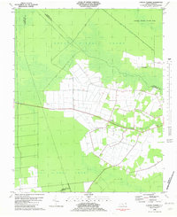
1982 Map of Lynchs Corner
USGS Topo · Published 1982About this map
The Great Dismal Swamp dominates this landscape, where the dense wilderness meets the agricultural reaches of Pasquotank County. This 1982 map illustrates the intricate network of artificial waterways like the Drainage Canal and various named ditches that once served timber and transport needs. Human presence is concentrated around Lynchs Corner and Horseshoe, with spiritual life anchored by Ramoth Gilead Ch and Mt Carmel Ch.
Find a feature on this map
18 named features on this map. Tap any name to fly to it.
Don’t see what you’re looking for? This feature index may not catch every label — zoom into the map to look around manually.
Map Details
Editions of this 1982 Lynchs Corner Map
This is the sole edition of this map. No revisions or reprints were ever made.
Other maps of this area

1906 · Beckford
USGS Topo · 1:48,000

1907 · Beckford
USGS Topo · 1:62,500

1919 · Suffolk
USGS Topo · 1:62,500

1940 · Beckford
USGS Topo · 1:62,500

1940 · Lake Drummond
USGS Topo · 1:62,500

1940 · South Mills
USGS Topo · 1:62,500

1945 · Lake Drummond
USGS Topo · 1:62,500

1952 · South Mills
USGS Topo · 1:62,500

1953 · Norfolk
USGS Topo · 1:250,000

1954 · Corapeake
USGS Topo · 1:24,000