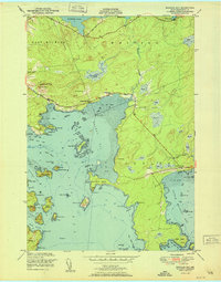
1951 Map of Machias Bay
USGS Topo · Published 1951About this map
Holmes Bay and the interconnected waters of Machias Bay define this mid-century coastal landscape in Washington County. The map details a maritime geography shaped by tidal flats and numerous islands, including Hog Island, Salt Island, and the prominent Avery Rock light. Inland, the transition from saltwater to freshwater is marked by Holmes Stream feeding from Gardner Lake and Holmes Pond. Small community centers such as North Cutler and the area around Holmes Bay Ch and Holmes Bay Sch reveal a settlement pattern tied to the shoreline. The terrain is notably punctuated by coastal elevations like Pettegrove Mtn and Woodruff Mtn, while the interior is characterized by extensive wetlands and heaths, reflecting the region's complex drainage and glaciated history.
Find a feature on this map
61 named features on this map. Tap any name to fly to it.
Don’t see what you’re looking for? This feature index may not catch every label — zoom into the map to look around manually.
Map Details
Editions of this 1951 Machias Bay Map
This is the sole edition of this map. No revisions or reprints were ever made.
Other maps of this area

1907 · Eastport
USGS Topo · 1:48,000

1908 · Eastport
USGS Topo · 1:62,500

1917 · Cutler
USGS Topo · 1:62,500

1918 · Machias
USGS Topo · 1:62,500

1918 · Cutler
USGS Topo · 1:62,500

1941 · Machias
USGS Topo · 1:62,500

1941 · Gardner Lake
USGS Topo · 1:62,500

1943 · Gardner Lake
USGS Topo · 1:62,500

1943 · Eastport
USGS Topo · 1:62,500

1945 · Eastport
USGS Topo · 1:62,500