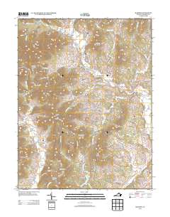
2013 Map of Madison
USGS Topo · Published 2013About this map
Shenandoah National Park defines the northwestern edge of this landscape, where the Blue Ridge Mountains descend into a series of distinctive ridges and hollows. Small agricultural settlements like Syria and Criglersville are connected by historical routes including the Old Blue Ridge Tpke. The terrain is marked by numerous family-named peaks and ridges, such as Utz Mountain, Blakey Ridge, and Gallihugh Mountain, which separate the many branches and runs of the upper Piedmont. This network of water, including the Rose River, Rapidan River, and Robinson River, historically supported the local economy. The southern reaches of the map show the transition from these mountain foothills to the more established seat at Madison, illustrating the rural settlement patterns that have persisted for generations along the eastern slope of the mountains.
Find a feature on this map
114 named features on this map. Tap any name to fly to it.
Don’t see what you’re looking for? This feature index may not catch every label — zoom into the map to look around manually.
Map Details
Editions of this 2013 Madison Map
This is the sole edition of this map. No revisions or reprints were ever made.
Other maps of this area

1892 · Gordonsville
USGS Topo · 1:125,000

1893 · Luray
USGS Topo · 1:125,000

1905 · Luray
USGS Topo · 1:125,000

1929 · Stony Man
USGS Topo · 1:48,000

1930 · Madison
USGS Topo · 1:48,000

1933 · Stony Man
USGS Topo · 1:62,500

1933 · Madison
USGS Topo · 1:62,500

1949 · Charlottesville
USGS Topo · 1:250,000

1956 · Charlottesville
USGS Topo · 1:250,000

1961 · Sperryville
USGS Topo · 1:62,500