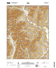
2019 Map of Madison
USGS Topo · Published 2019About this map
Madison serves as the seat of local government, anchored by the Madison County Courthouse and a cluster of family-named burial grounds like Cedar Hill Cem and Gordon Cem. The landscape is defined by the sharp rise of the Blue Ridge, where the eastern boundary of Shenandoah National Park meets established valley settlements. Agricultural roots remain evident at the Baker Farm and in the naming of rural crossroads like Criglersville, Aylor, and Graves Mill. These communities are tied to the drainage systems of the Rose River, Robinson River, and Rapidan River, which carve deep incisions through the terrain. To the west, the topography reaches its highest points at Doubletop Mtn and Utz Hightop, while lower ridges such as German Ridge and Blakey Ridge partition the numerous creek hollows that have historically dictated the placement of mountain roads and small family cemeteries.
Find a feature on this map
128 named features on this map. Tap any name to fly to it.
Don’t see what you’re looking for? This feature index may not catch every label — zoom into the map to look around manually.
Map Details
Editions of this 2019 Madison Map
This is the sole edition of this map. No revisions or reprints were ever made.
Other maps of this area

1892 · Gordonsville
USGS Topo · 1:125,000

1893 · Luray
USGS Topo · 1:125,000

1905 · Luray
USGS Topo · 1:125,000

1929 · Stony Man
USGS Topo · 1:48,000

1930 · Madison
USGS Topo · 1:48,000

1933 · Stony Man
USGS Topo · 1:62,500

1933 · Madison
USGS Topo · 1:62,500

1949 · Charlottesville
USGS Topo · 1:250,000

1956 · Charlottesville
USGS Topo · 1:250,000

1961 · Sperryville
USGS Topo · 1:62,500