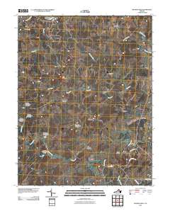
2010 Map of Madison Mills
USGS Topo · Published 2010About this map
The Rapidan River and its numerous tributaries, including Beaverdam Run, Great Run, and Beautiful Run, carve a network through this Piedmont landscape at the border of Madison and Orange Counties. Named for the industrial heritage of the region, Madison Mills sits at a critical bend in the river, joined by other historic crossroads like Twymans Mill and Locust Dale. The terrain is punctuated by significant rises such as Lost Mountain, while the hydrology is defined by a sequence of man-made structures including Malvern Dam and a series of numbered impoundments on Beautiful Run. Local genealogy is anchored by the Kemper Cemetery and long-standing hamlets like Radiant, Aroda, and Burnt Tree, reflecting a rural settlement pattern that follows the winding course of ancient roads like Spicers Mill Rd and Jones Mill Rd.
Find a feature on this map
43 named features on this map. Tap any name to fly to it.
Don’t see what you’re looking for? This feature index may not catch every label — zoom into the map to look around manually.
Map Details
Editions of this 2010 Madison Mills Map
This is the sole edition of this map. No revisions or reprints were ever made.
Other maps of this area

1892 · Gordonsville
USGS Topo · 1:125,000

1930 · Madison
USGS Topo · 1:48,000

1933 · Madison
USGS Topo · 1:62,500

1935 · Charlottesville
USGS Topo · 1:62,500

1939 · Charlottesville
USGS Topo · 1:62,500

1949 · Charlottesville
USGS Topo · 1:250,000

1949 · Charlottesville
USGS Topo · 1:62,500

1956 · Charlottesville
USGS Topo · 1:250,000

1961 · Gordonsville
USGS Topo · 1:62,500

1961 · Rapidan
USGS Topo · 1:62,500