
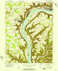
1953 Map of Madison West
USGS Topo · Published 1954About this map
Hanover College overlooks the Ohio River from its high bluff, marking a landscape defined by dramatic elevation changes and deeply incised stream valleys. This mid-century survey illustrates the rural interface between Indiana and Kentucky, where the river serves as both a political boundary and a central transport artery. To the north, Clifty Falls State Park and the State Hospital frame the outskirts of Madison, while the Pennsylvania RR cuts through the terrain near the river's edge. The Indiana side is dotted with landmarks like the Antioch Grange and Hanover Beach, contrasting with the more dissected ridges of Kentucky. These ridges, including Retreat Ridge and Pleasant Ridge, are separated by numerous small waterways such as Corn Creek and Moreland Creek, which drain into the wide floodplain of Lee Bottom.
Find a feature on this map
63 named features on this map. Tap any name to fly to it.
Don’t see what you’re looking for? This feature index may not catch every label — zoom into the map to look around manually.
Map Details
Editions of this 1953 Madison West Map
2 editions found
Other maps of this area

1939 · Bethlehem
USGS Topo · 1:24,000

1939 · Madison West
USGS Topo · 1:24,000

1948 · Bethlehem
USGS Topo · 1:24,000

1948 · Madison West
USGS Topo · 1:24,000

1953 · Bedford
USGS Topo · 1:24,000

1953 · Madison East
USGS Topo · 1:24,000

1953 · Bethlehem
USGS Topo · 1:24,000

1956 · Volga
USGS Topo · 1:24,000

1956 · Kent
USGS Topo · 1:24,000

1956 · Clifty Falls
USGS Topo · 1:24,000