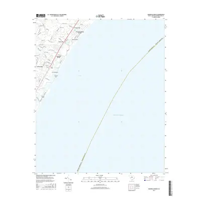
2017 Map of Magnolia Beach
USGS Topo · Published 2017About this map
Pawleys Island and the surrounding barrier island communities of the Waccamaw Neck are meticulously documented in this 2017 survey. The landscape is defined by the transition from the Atlantic Ocean and Long Bay to the marshy network of Pawleys Island Creek and Clubhouse Creek. Coastal development is prominent, ranging from the established neighborhoods of Georgieville and Annieville to the beachfront stretches of North Litchfield Beach and Magnolia Beach. The map illustrates the specialized geography of the South Carolina coast, where landforms like the Litchfield Spit separate tidal waters such as Midway Inlet from the open sea. Inland, the map captures the residential and recreational expansion near Parkersville, providing a detailed look at the modern street network including Kings River Rd and Baskervill Dr.
Find a feature on this map
57 named features on this map. Tap any name to fly to it.
Don’t see what you’re looking for? This feature index may not catch every label — zoom into the map to look around manually.
Map Details
Editions of this 2017 Magnolia Beach Map
This is the sole edition of this map. No revisions or reprints were ever made.
Other maps of this area

1937 · Myrtle Beach
USGS Topo · 1:48,000

1940 · Myrtle Beach
USGS Topo · 1:62,500

1942 · North Island
USGS Topo · 1:24,000

1942 · Magnolia Beach
USGS Topo · 1:24,000

1942 · Waverly Mills
USGS Topo · 1:24,000

1943 · Brookgreen
USGS Topo · 1:24,000

1943 · Plantersville
USGS Topo · 1:24,000

1949 · Georgetown
USGS Topo · 1:250,000

1967 · Georgetown
USGS Topo · 1:250,000

1974 · Georgetown
USGS Topo · 1:250,000