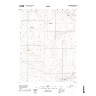
2018 Map of Mahogany Mountain
USGS Topo · Published 2018About this map
Mahogany Mtn and the Little High Rock Mountains dominate this high-desert landscape in northern Washoe County. The map details a complex network of ephemeral drainage and essential water sources, centered on Big Mahogany Reservoir. Deep geographic features like High Rock Canyon and Little High Rock Canyon cut through the volcanic terrain, while the eastern edge is defined by the Division Range. The distribution of named water sources such as Denio Camp Springs, Al Owens Spring, and Pappys Corral Spring indicates the area's historical reliance on reliable springs for livestock and transit through this arid basin-and-range environment. The presence of Sage Hen Spring and Cherry Spring further highlights the scattered points of biological and human activity within the larger expanse of northwestern Nevada.
Find a feature on this map
22 named features on this map. Tap any name to fly to it.
Don’t see what you’re looking for? This feature index may not catch every label — zoom into the map to look around manually.
Map Details
Editions of this 2018 Mahogany Mountain Map
This is the sole edition of this map. No revisions or reprints were ever made.
Other maps of this area

1889 · Long Valley
USGS Topo · 1:250,000

1954 · Vya
USGS Topo · 1:250,000

1958 · Vya
USGS Topo · 1:250,000

1962 · Vya
USGS Topo · 1:250,000

1972 · Mahogany Mtn
USGS Topo · 1:24,000

1972 · High Rock Lake
USGS Topo · 1:24,000
1972 · Yellow Hills East
USGS Topo · 1:24,000
1972 · Yellow Hills West
USGS Topo · 1:24,000

1978 · Hart Mountain
USGS Topo · 1:24,000
1979 · Nellie Spring Mtn
USGS Topo · 1:24,000